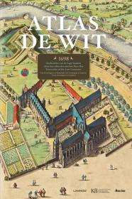


Atlas De Wit: City Atlas of the Low Countrie
城市建筑水彩手绘手稿 超大本 荷兰语、英语、法语三语对照
¥ 728 九品
库存4件
河北衡水
认证卖家担保交易快速发货售后保障
作者Marieke Van Delft and Peter Van Der Krogt
出版社Lannoo Publishers
ISBN9789401401890
出版时间2014
装帧精装
货号11楼-CK
上书时间2022-10-28

- 在售商品 暂无
- 平均发货时间 9小时
- 好评率 暂无
- 店主推荐
- 最新上架


商品详情
- 品相描述:九品
-
Hardcover: 320 pages
Publisher: Lannoo Publishers; Large Edition edition (April 7, 2014)
Language: English
ISBN-10: 9401401896
ISBN-13: 978-9401401890
Product Dimensions: 36.3 x 4 x 54.6 cm
这本书约15斤
- 商品描述
-
这本书是宏伟的,超大开本手绘荷兰和比利时的185个不同城市的地图,包括,阿姆斯特丹,安特卫普,布鲁塞尔,,豪达,吕伐登,莱顿,米德尔堡和兹沃勒等等城市。并非所有的板块都是地图,一些是重要的建筑物或城市景观,尤其是在阿姆斯特丹。
通常跨越两页,都是全色的。你可以看到钢笔的每一个划痕,墙上的每个人,屋顶上的每一个颜色斑点。
附上的文本也非常有用和可用的荷兰语、英语和法语。对于较大的城市,文本解释了城市的历史和发展的城市规划,并给出了背景信息的建筑物或其他特点的地图。
A historical atlas from 1698 with 151 city maps from the Northern and Southern Netherlands, from Groningen to Lille.
- Winner of the first prize in the category of atlases at the 26th International Cartographic Conference of the International Cartographic Association, and was described by the jury as 'A fantastic facsimile of a famous sparkling hand-coloured city atlas made in 1698'. - Discover the Google Earth of the Dutch Golden Age! - A historical atlas from 1698 with 151 city maps from the Northern and Southern Netherlands, from Groningen to Lille. - A book of great cultural and artistic importance. Only 5 copies of the original atlas are known worldwide. - Contains beautiful, originally hand-coloured maps, drawn from a bird's eye view. - A facsimile on true scale with a new introduction and a detailed description per map by Marieke van Delft and Peter van der Krogt. - A must-have for all enthusiasts of history and old maps. Atlas De Wit is a unique, historical atlas of cartographer Frederick de Wit with 158 city maps, city views and engravings from the Northern and Southern Netherlands (today's Netherlands, Belgium and French Flanders). This facsimile contains full-size images of the beautiful, original hand-coloured cards, which are drawn in perspective. The maps provide a visual perspective on the history of the 17th century, from Groningen to Cambrai. This title is completed with introductory and detailed descriptions that make this historical atlas map accessible to all lovers of history and old maps. Text in English, French & Dutch.

— 没有更多了 —
以下为对购买帮助不大的评价